*Note: Aretas RTLS Cloud based software is now available!
See: http://www2.aretas.ca/aretas-iot-cloud-rtls/
RTLS (real-time location services / systems) are wireless systems using several different technologies (UWB, BLE, Sonar etc) to help provide asset or people location data in real time. The spatial and temporal resolution of the various LBS systems can be very different. Spatial resolution ranges from meters to millimeter precision. Temporal resolution also ranges from milliseconds to minutes (or arbitrary time values). Other types of RTLS systems are location classifiers. These types of systems use arbitrary location naming and train their system via machine learning to recognize characteristics of tag signals associated with location names. You can train the system to recognize when your asset or tag is in “Office A” but not know precisely where the object is in real space. RTLS systems can be used indoors and outdoors. Many systems also utilize other technologies (accelerometer, altimeter, etc) to amplify the resolution or confidence of the location estimate.
Aretas has added features to the Sensor Edge IoT Cloud platform which offer RTLS data ingest and Location Based Analytics and real time visualization. Features include:
- REST Based endpoint to update and query RTL Tag objects (use any RTLS hardware system)
- Extensions to the Building Map system to support real-time RTLS positions within the Space
- A new Location Based Analytics System including support for:
- Boundary detection and State Change / Alerting (geo-fencing)
- Collision Detection, Prediction and Notification
- Asset / Tag Dimensions to support Collision detection and Geofence parameters for different sized objects
- High speed RTL ingest and visualization (tested to 5000 objects with 100ms update precision and beyond)
Analytics Visualizations
High speed cloud-based RTL capability (view RTL data anywhere in the world)
The animation above shows a simulation of the Aretas RTL visualization system using synthetic agents to update the RTL API with Tag Location data every 100ms. The system is performing collision detection, geo-fencing and location trail updates in real-time. The Tag location data (location, last known bearing, last recorded velocity, spatial dimensions, Tag trail data, etc) is available by websocket or REST.
The main advantage to a cloud or edged based solution is the ability for any device or platform and concurrent, multi-user support. The Aretas RTLS system also works with mobile devices and mobile browsers (phone, tablet, etc)
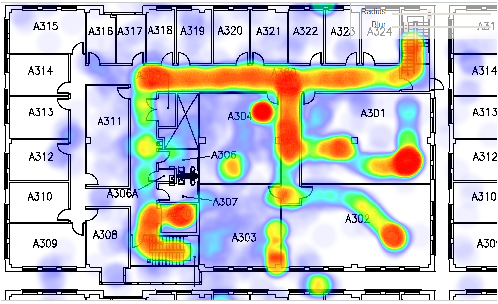
Location Density / Usage
Query historical location data to gain insight into traffic patters, space utilization or other features
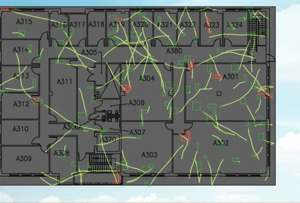
Noodle Maps / Trail Maps
Query where a Tag has traveled over a specific time frame.
Combine with other Aretas Location Based Analytics (to view real time sensor data)

Building Map Sensor Visualizations
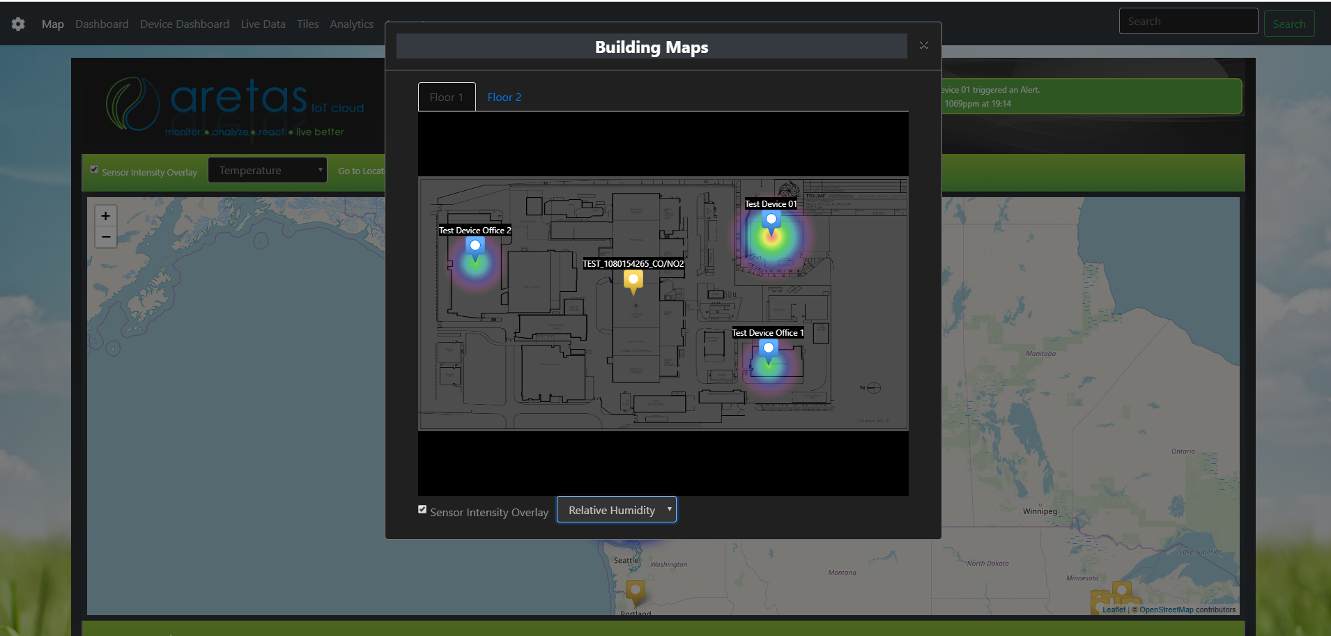
Location Based Analytics and Insights are an exciting addition to the Aretas IoT Analytics portfolio.

0 Comments